Services: Commercial Site Plan Feasibility & Design
 If you are interested in developing a commercial property, there are a number of factors which you must consider prior to proceeding with final design of a commercial site development plan. Local, state, and federal land use regulations with regard to zoning, inland wetlands and watercourses, health, and traffic can all greatly impact the development potential of a commercial property. Since these factors vary from project to project depending on a property’s terrain, natural resources, and location, it is advisable that aCommercial Site Plan Feasibility be performed prior to final design to identify any limitations which may exist on the property.
Commercial Site Layout Considerations
Whether you are looking to build a new restaurant, retail shop, office building, or combination thereof, it makes sense to perform a Commercial Site Plan Feasibility. The planning, civil engineering, land surveying, and environmental services staff of Arthur H. Howland & Associates, P.C. can help you identify the various factors associated with a commercial property and then help you develop possible layouts for the development that will meet your needs and goals for the site while still complying with local, state, and federal land use regulations and guidelines.
Wetlands, Watercourses, & Other Natural Resources
One of the first steps in determining the ability of a property to be developed is to determine the existence of any environmentally sensitive areas on or near the property. The location of wetlands, watercourses, floodplain, vernal pools, steep slopes, and other environmentally sensitive areas on or in relation to a property affects the ability of a property to be developed. In the feasibility stages of the project, the location of wetlands and watercourses are typically estimated based on a field visit and available state and local wetland and soil mapping. As a project moves closer to the final design phase, more accurate limits of existing wetlands and watercourses must be field delineated, located by a survey field crew, and then incorporated into property surveyto allow for the final design of the commercial site plan. In order to protect these sensitive areas, development near these areas is regulated by local, state, and federal land use agencies. To protect wetlands and watercourses, most municipalities in the State of Connecticut have established regulated areas within certain distances of a wetland or watercourse where all development is regulated by the local Inland Wetlands & Watercourses Commission. In order for development to be allowed within a regulated area, the applicant must prove to the commission that a subject wetland or watercourse will not be detrimentally impacted by the development proposed. Sometimes projects that contain no wetlands or that are completely outside of a wetland regulated area may also be regulated by the local Inland Wetlands & Watercourses Commission due to the project’s location upgradient of a wetland or watercourse or the project’s drainage connectivity to the watercourse or wetland.
Development within a watercourse floodplain is typically not allowed. In the rare cases where development or filling of a floodplain is allowed, compensation must be made by the developer, as part of the site development plan process, to provide additional floodplain storage to make up for any floodplain storage volume lost by development. A floodplain analysis of a watercourse may also be required to determine the impact that filling within a floodplain may have on flood elevations within a watercourse’s banks. Any proposed construction or disturbance within a floodplain must ultimately be approved by the United States Army Corps or Engineers.
Zoning Compliance
Another initial step of the Commercial Site Plan Feasibility process is to determine the zone and uses allowed where the project is located. Just because a property is located in a commercial zone does not necessarily mean that all commercial uses are allowed within that zone. Many municipalities have multiple commercial zones that vary in what uses they allow. Sometimes a certain commercial use may not be allowed in a particular zone. Other times, a certain use may only be allowed through the special permit process.
Once it is determined that the desired use is allowed within the zone, it is then necessary to identify all zoning regulations pertaining to the zone where the project is located. These zoning regulations typically make reference to building setbacks, parking setbacks, building heights, building coverage, site impervious coverage, parking stall sizes, driveway widths, driveway grading, landscaping requirements, driveway sight distance and other requirements that are specified for all new construction within that zone. The number of parking spaces required for a particular use based on building area devoted to that use is also identified within a municipality’s zoning regulations. Occasionally zoning regulations may even require that certain uses be serviced by public water or sewer for the use to be allowed in a particular zone.
Commercial Site Layout
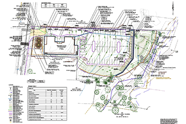
Once a site’s environmentally sensitive areas are located and all pertinent zoning regulations are identified, it is then possible to begin developing layouts for the desired commercial development. During this phase, it is essential to work with the client to develop a clear understanding of their needs and goals for the site. Once there is a clear understanding of the client’s vision for the site, it is then possible for the engineering and planning staff of Arthur H. Howland & Associates, P.C. to generate potential commercial layouts that strive to meet the client’s goals while remaining cognizant of local, state, and federal regulations and any environmentally sensitive areas. Feasibility Layouts typically display scenarios for placement of proposed buildings, parking areas, driveways, stormwater management areas, drainage systems, wastewater systems, and any other utilities that may service the property. Once the Feasibility Layouts are developed, they are then presented to the client to determine the direction the project will go next. Once the Feasibility Layouts are presented, the client has several options. They may choose to pursue one of the layouts presented or they may decide to have additional Feasibility Layouts developed which may involve altering an existing layout or developing a new layout altogether. In extreme cases where environmentally sensitive areas or federal, state, and local regulations do not allow development to the extent desired by the client, the project may be abandoned altogether.
Commercial Site Plan Design
Once the client selects a Feasibility Layout, it is typically a good idea to informally present the desired layout to the local zoning and wetland regulatory commissions or agencies. These informal meetings typically provide the client with initial feedback on the project. The feedback from these informal meetings can then be used to develop final design plans that address the initial concerns prior to formal submission. Once the client gives the formal go ahead, the engineering staff of Arthur H. Howland & Associates, P.C. works to develop final design plans from the preliminary Feasibility Layout.
During this phase, the more detailed aspects of the project are addressed. Site grading is provided through the use of spot grades and contour lines. A cuts and fill analysis will typically be included during the development of site grading to minimize the need for removing excess soil material from a site or require additional fill material to be trucked onto a site. Detailed information regarding the proposed drainage system, sewer or septic system, water supply system , and other site utilities is also provided. A detailed stormwater management system which attenuates any potential impact to peak runoff flow rates and stormwater quality is analyzed and designed. Sedimentation and Erosion Control measures and construction sequences are designed and developed to minimize any effect the development may have on wetlands and watercourses during construction. Depending on the types of vehicles that will use a site, a traffic circulation plan will be developed that shows how cars, garbage trucks, box trucks, tractor trailers, emergency vehicles, and any other type of vehicle would be able to maneuver the site. During the design phase, it is also necessary to ensure that all site driveways have appropriate intersection and stopping sight distance. Details regarding construction materials and methods are also specified at this time. In addition, we also work with other industry professionals such as landscape architects and wetland specialists who aid in developing compliant landscaping plans and wetland mitigation plans.
Once the final design plans are developed, they are then submitted with the appropriate application and presented to the local land use commissions and agencies having jurisdiction over the project for approvals. If the project is proposed in the vicinity of an existing wetland or watercourse, an Inland Wetland & Watercourse Permit would be required. Following inland wetland approval or if no inland wetland approval is required, the project will then be submitted to obtain local planning and/or zoning apporval. Following all local approvals, the project would then need to be submitted for any other state and federal permits that would apply to the project. During the local, state, and federal permitting process, the reviewing agencies may offer comments or express concerns over issues relating to the site development plan. Depending on the comments, the design engineer may need to revise the plans to address any concerns that are raised. This iterative process, which involves some back and forth, typically results in a project approval and a development where all parties concerned are comfortable.
Proven Experience and Results
The design and permitting process associated with commercial site plans can be a difficult yet rewarding experience. The land surveying, planning, civil engineering, and environmental services staff of Arthur H. Howland & Associates, P.C. has designed and presented many commercial site development projects that have successfully been approved by various land use commissions and agencies throughout the State of Connecticut. Our established relationships with various local, state, and federal agencies combined with our ability to collaborate with other industry professionals to produce and present attractive, value engineered designs sets us apart from our competition. If you are interested in developing a commercial property, contact us at (860) 354-9346 so that we can show you some of our previous projects and get you on your way to a successful commercial development.