Services: Wetland Soil & Watercourse Delineation
 The presence of wetland soils, watercourses or water bodies on or in close proximity to a project greatly influences the restrictions and regulations of activities allowed. At Arthur H. Howland & Associates, we understand this and therefore make the investigation and delineation of these features one of our first steps in a project. A preliminary investigation of a property using published soil surveys with aerial photographs allows us the opportunity to identify constraints based on wetland features and advise our clients on the risks and probability of approval for their projects. This preliminary step often saves our clients time and money by helping them to make informed decisions prior to the purchase of a property or progressing too far in a project.
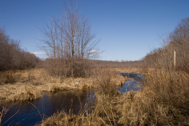
After identifying the potential presence of wetland soils, watercourses, and waterbodies on a property, our soil scientist is sent to the site to delineate the actual wetland boundaries. During the site visit, our in-house soil scientist uses a spade and auger to extract small soil cores to observe the profile and characteristics of the soil. Since soil characteristics vary based on mineral content, oxygen levels, organic material, biological life, and interaction with water, the soil scientist must examine each core sample to determine if the collected sample demonstrates the properties of a wetland soil. Based on the results of the examination, the soil scientist is then able to determine wetland boundaries of a site. Once the watercourse or wetland boundaries are determined, they are then marked with ribbon for future location by our survey field crew. The ribbon also serves as a visual reference for wetland commission members and the property owners as to the sensitive nature of the delineated areas.
Once the field work is complete, a wetland report is prepared by our soil scientist. This report describes the property and the location of any wetland soils on the site. It also includes the a general map of the area, observations made during the delineation, as well as, any recommendations for areas of concern on the site. This report is then submitted as part of an Inland Wetlands & Watercourse Permit Application to the respective municipality’s Inland Wetland Commission and Land Use Departments for reference during the approvals process.
At Arthur H. Howland & Associates, P.C we understand that your time and money are extremely valuable to you. If you are considering the purchase of a piece of property or already have a property and want to consider development possibilities,contact us at (860) 354-9346 so that we can conduct a preliminary wetland review of the property to help you make informed decisions and plans for a successful land development project.